
Call: +251 99 466 6686  ·  WhatsApp: +251 921 650 347 Jigjiga, Somali Region · Ethiopia

Project overview & information

The project at a glance, what the survey work found, the resource figures, the borehole plan, the development concept — and the project information available to partners.

On this page: At a glance Location Survey findings Resource figures Borehole plan Technical development Processing Information for partners Due diligence Request information
1. Project at a glance

Project identity at a glance

ItemDetail
ProjectSalt production & processing
DeveloperNoolays Salt Producer Cooperative
CountryEthiopia
RegionSomali Regional State
ZoneNogob Zone
WoredaDihun Woreda
KebeleJajabe Kebele
Resource areaHabulay Saline River Basin
Development modelPilot → Commercial → Industrial
Primary resourceSaline water / salt resource
Initial focusSolar evaporation and raw-salt production
Long-term focusProcessing, refining, iodization, packaging and industrial products
Partnership soughtInvestment + technology + engineering + markets
Project figures and technical parameters are preliminary and subject to verification through ongoing studies, laboratory testing, engineering design and independent due diligence.
2. Location

Where the project is

The project sits on the Habulay saline river basin, where surface salt crusts and shallow saline groundwater occur naturally. The site provides the foundation for a solar-based salt-production operation, subject to detailed resource characterisation, engineering assessment, environmental requirements and commercial feasibility.

PointDetail
Resource areaHabulay Saline River Basin
Project locationGansale Village (central point)

Satellite imagery, site maps, boundary information and access information form part of the data room available to qualified partners.
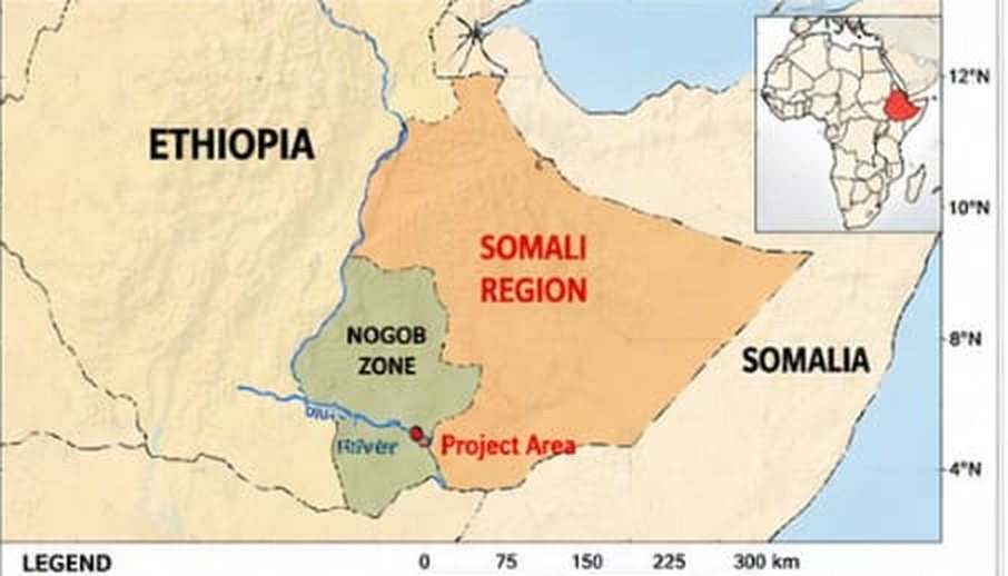
Location map of the project area
Project location map: red marker shows the project area in Nogob Zone, Somali Regional State.
3. Resource opportunity

What the survey work found

Preliminary field work and remote-sensing analysis have been undertaken to understand salinity characteristics, brine occurrence, surface conditions, the geological setting, hydrogeological conditions, potential evaporation areas and site accessibility.

Hydrochemical & saline potential

ParameterValue rangeInterpretation
TDS>250,000 mg/LHypersaline — suitable for commercial salt extraction
Na⁺ / Cl⁻ ratio0.9 – 1.1Near-marine composition
SO₄²⁻ contentHighIndicates gypsum and anhydrite dissolution
pH6.5 – 7.5Neutral to slightly saline
Evaporation rate≈7 – 9 mm/dayHigh potential for natural solar evaporation ponds

Geological background

The Habulay River area lies within the south-eastern Ethiopian plateau and is structurally part of the Ogaden Basin. The stratigraphic succession observed and confirmed by field and remote sensing studies includes:

Geological periodFormationLithologySalinity potential
CretaceousKorahe Formation (Kg1–Kg2)Alternating gypsum, shale, limestone, anhydriteHigh — principal evaporite sequence and source of salt brine
CretaceousMustahil Formation (Km)Marl, limestone, sandstoneModerate — secondary salinity contribution
CretaceousFerfer Formation (Kf)Shale, dolomite, anhydriteModerate to high — contributes sulphate brine
JurassicGabredarre & Agula FormationsLimestone and marlModerate — acts as aquifer host for saline circulation
JurassicUrandab & Antalo FormationsShale, marl, limestoneLow — confining and structural support units

Geomorphological features

  • Topography: gently undulating plains with low-relief ridges trending NE–SW, controlled by regional fault systems.
  • Drainage pattern: seasonal river channels (wadis) drain saline brines towards low-lying evaporation depressions.
  • Evaporative depressions: satellite analysis indicates multiple brine concentration zones along the Habulay River, coinciding with gypsum-bearing outcrops of the Lower Korahe Formation.
  • Surface features: light-toned reflective surfaces observed in multispectral imagery correspond to salt crusts and evaporite layers.

Remote sensing & salinity analysis

  • Spectral indicators: high reflectance in shortwave-infrared and near-infrared bands, indicating sodium chloride and gypsum surfaces.
  • Thermal analysis: surface-temperature anomalies up to +4 °C above surroundings, consistent with salt crusts and brine concentration.
  • Brine ponds: approximately 15–20 natural evaporation ponds identified with high salinity signatures (albedo index >0.45).
4. Preliminary resource estimate

Indicative resource figures

ComponentEstimated coveragePotential yield
Surface salt crusts≈2.5 km²20,000 – 25,000 tons (NaCl)
Shallow brine zone3 – 5 m depth45,000 – 60,000 m³ brine
Gypsum / anhydrite beds10 – 15 m thick500,000 – 700,000 tons (gypsum equivalent)

Evaporation-pond areas

15 – 20 ha of favourable evaporation-pond areas identified

Resource life (preliminary)

>10 years at the planned abstraction rate (preliminary)

Survey basis

Remote sensing (satellite) and stratigraphic correlation with the Korahe Basin

Preliminary, not certified. These are preliminary estimates from remote-sensing analysis and field studies, prepared for project development. They are not an independently certified mineral resource statement and must not be read as a production forecast. Recoverable quantities depend on evaporation performance, brine management and pilot testing — which is exactly what the pilot stage is for. How we describe these figures (PDF)
5. Preliminary borehole exploration plan

Preliminary 5-borehole exploration plan

The cooperative's concept map proposes five shallow exploration boreholes along the Habulay River corridor, inside an identified 150 ha permit area. Each location targets a different part of the brine system so that salinity and water chemistry can be compared between locations before the pilot evaporation ponds are designed.
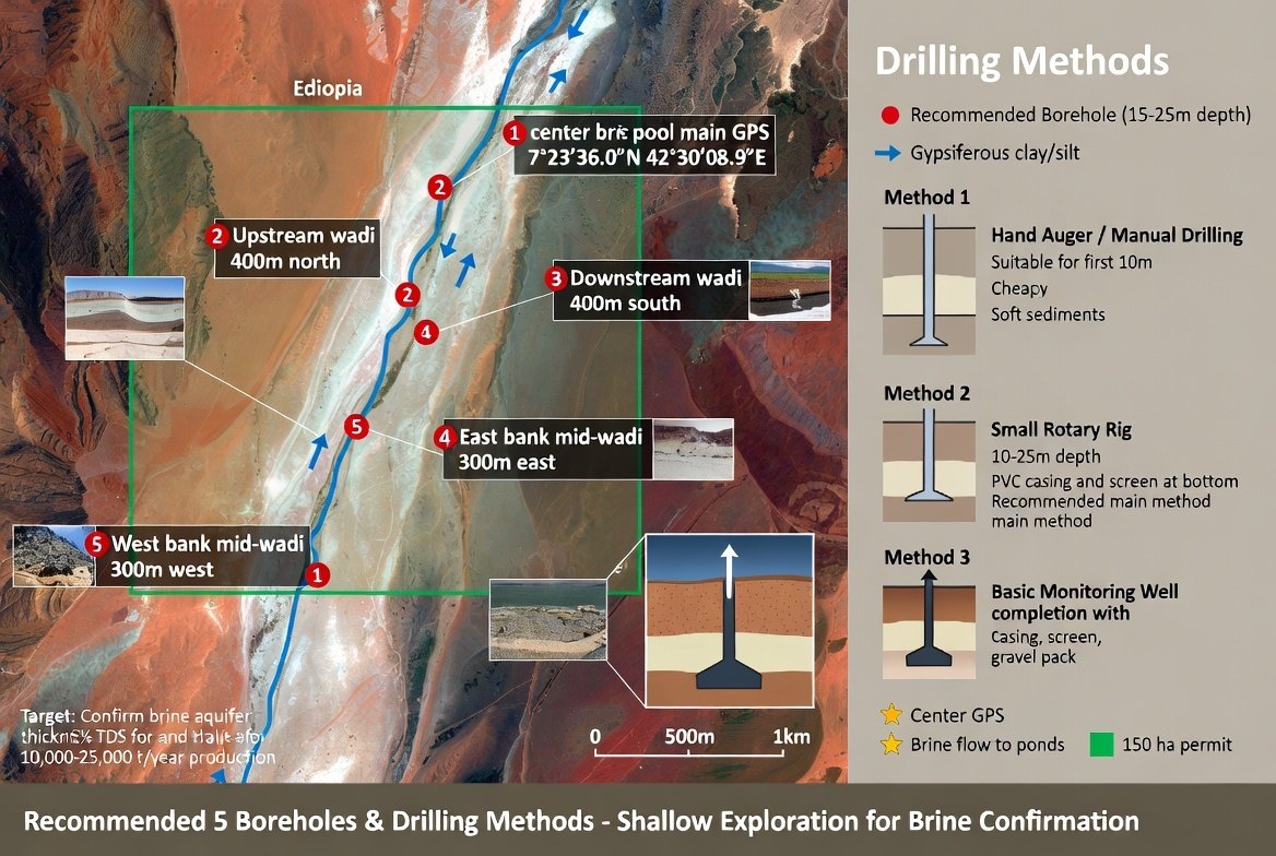
Concept map: five proposed exploration boreholes and drilling methods
Concept map: five proposed boreholes and drilling methods, Habulay corridor.

Purpose of the boreholes

  • Confirm brine occurrence and aquifer characteristics
  • Collect representative samples for laboratory analysis
  • Compare salinity and water chemistry between locations
  • Use the results to refine the pilot evaporation design

Locations

#Location
1Centre brine pool (main GPS)
2Upstream wadi
3Downstream wadi
4East bank, mid-wadi
5West bank, mid-wadi

Drilling methods considered

MethodNote
Hand auger / manual drillingSuitable for the first 10 m in soft sediments; low cost.
Small rotary rig10–25 m depth with PVC casing and screen at the bottom. Recommended as the main method.
Monitoring-well completionCasing, screen and gravel pack for repeated sampling and water-level monitoring.

≈150 ha identified permit area · 5 shallow exploration boreholes (15–25 m depth) · Brine confirmation for a 10,000–25,000 t/year concept

This is a preliminary planning graphic and must be field-verified before any drilling. Borehole positions, depths and the permit area are subject to survey, land access and regulatory confirmation.
6. Technical development

From resource to production

The proposed technical development combines several interconnected systems. The final configuration will follow engineering studies, resource confirmation and economic analysis.

A. Brine / saline-water system

  • Boreholes where technically appropriate
  • Pumps and brine-collection systems
  • Channels and pipelines
  • Storage and control structures

B. Solar evaporation

  • Pre-concentration ponds
  • Evaporation ponds
  • Crystallization ponds
  • Brine-transfer systems
  • Salt harvesting areas

C. Harvesting & handling

  • Mechanical harvesting
  • Controlled manual operations
  • Salt collection
  • Transport
  • Raw-salt storage
7. Processing & value addition

The long-term development concept is not limited to raw salt

  • Raw salt
  • Washing
  • Purification
  • Drying
  • Crushing / milling
  • Screening & grading
  • Iodization
  • Packaging
  • Market

Edible salt

Refined and iodized salt for human consumption, subject to applicable Ethiopian standards, laboratory testing, certification and regulatory requirements.

Industrial salt

Salt for industrial customers requiring specific purity, particle size and chemical specifications.

Livestock salt

Products developed for livestock applications according to appropriate technical and regulatory requirements.

Raw solar salt

Bulk raw salt for customers with suitable processing capacity.

Additional products may be considered after technical and market validation.
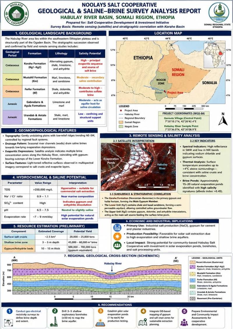
8. Survey report & next steps

Recommendations from the survey analysis

  1. Conduct geo-electrical resistivity surveys to define brine depth and extent.
  2. Drill 3–5 shallow exploratory boreholes (≤50 m) to map the brine aquifer.
  3. Establish pilot solar evaporation ponds (1 ha each) for production testing.
  4. Integrate GIS-based mapping of gypsum and salt-crust zones for sustainable extraction planning.
  5. Prepare Environmental and Community Impact Assessments for cooperative development.
Request the survey summary. The full report and its underlying data are provided to qualified partners under confidentiality. The document index is in section 9 of this page.
Survey analysis report summary sheet
Summary sheet: Geological & Saline-Brine Survey Analysis Report, Habulay River Basin.
9. Information & data room

Project information for partners

How this works. A serious investor first identifies their organisation and area of interest using the request form in section 11; Noolays then provides the appropriate documents under a confidentiality and due-diligence arrangement. Nothing sensitive is published here as a download.

The data room index

Subject to confidentiality and the nature of the request, the investor information package can include:

Corporate documents

  • Cooperative registration
  • Organizational documents
  • Governance information

Land & legal

  • Land documentation
  • Site handover documentation
  • Relevant permits
  • Regulatory documentation

Technical

  • Resource studies
  • Geological information
  • Hydrogeological information
  • Survey data
  • Maps and coordinates
  • Engineering concepts

Laboratory

  • Brine analyses
  • Raw-salt analyses
  • Product testing
  • Quality-control information

Environmental

  • Environmental studies
  • Environmental-management information
  • Relevant regulatory documentation

Commercial

  • Market studies
  • Customer requirements
  • Product specifications
  • Logistics assessment

Financial

  • Project cost estimates
  • Capital expenditure, operating expenditure
  • Financial model
  • Investment scenarios

Development

  • Pilot plan
  • Implementation schedule
  • Procurement plan
  • Expansion strategy

Technical data disclaimer — how we describe these preliminary figures (PDF)

10. Due diligence

Independent verification is welcome

A potential investor may conduct or commission any of the following, and Noolays will cooperate with the process.

  1. Legal due diligence

    Corporate and contractual review.

  2. Land & permit verification

    Land documentation, site handover and permits.

  3. Technical due diligence

    Resource, engineering and hydrogeology.

  4. Resource & laboratory verification

    Sampling, brine and product analysis.

  5. Environmental review

    Environmental studies and management measures.

  6. Engineering assessment

    Pond design, pumping, processing configuration.

  7. Market assessment

    Product specifications, customers, logistics.

  8. Financial model review

    Capital and operating cost assumptions.

  9. Investment decision

    Structure, milestones and agreements.

11. What happens next

From your request to a decision

  1. We acknowledge your request within five working days.
  2. We send introductory project information and answer your first questions.
  3. If there is mutual interest, we agree a confidentiality arrangement.
  4. We provide the agreed data-room material and arrange a site visit.
  5. You complete your technical, legal and financial assessment, and we discuss structure.

Contact for project information: Abdifatah Hussein — [email protected] / +251 921 650 347

Investor inquiry form

Tell us who you are and which documents you need. We send the investor information package after a confidentiality arrangement.

Partnership interest

Your message is sent directly to the cooperative’s email inbox; this page keeps no record of the request. If sending fails, your email app opens with the details filled in instead.

These figures are preliminary — and the pilot is how we confirm them

If the resource case interests you, the next step is the investment structure and the information set available for due diligence.

WhatsApp